• KGS/USD = 0.01144 0%
  • KZT/USD = 0.00205 0%
  • TJS/USD = 0.10761 -0.19%
  • UZS/USD = 0.00008 0%
  • TMT/USD = 0.28490 -0.28%
  • KGS/USD = 0.01144 0%
  • KZT/USD = 0.00205 0%
  • TJS/USD = 0.10761 -0.19%
  • UZS/USD = 0.00008 0%
  • TMT/USD = 0.28490 -0.28%
  • KGS/USD = 0.01144 0%
  • KZT/USD = 0.00205 0%
  • TJS/USD = 0.10761 -0.19%
  • UZS/USD = 0.00008 0%
  • TMT/USD = 0.28490 -0.28%
  • KGS/USD = 0.01144 0%
  • KZT/USD = 0.00205 0%
  • TJS/USD = 0.10761 -0.19%
  • UZS/USD = 0.00008 0%
  • TMT/USD = 0.28490 -0.28%
  • KGS/USD = 0.01144 0%
  • KZT/USD = 0.00205 0%
  • TJS/USD = 0.10761 -0.19%
  • UZS/USD = 0.00008 0%
  • TMT/USD = 0.28490 -0.28%
  • KGS/USD = 0.01144 0%
  • KZT/USD = 0.00205 0%
  • TJS/USD = 0.10761 -0.19%
  • UZS/USD = 0.00008 0%
  • TMT/USD = 0.28490 -0.28%
  • KGS/USD = 0.01144 0%
  • KZT/USD = 0.00205 0%
  • TJS/USD = 0.10761 -0.19%
  • UZS/USD = 0.00008 0%
  • TMT/USD = 0.28490 -0.28%
  • KGS/USD = 0.01144 0%
  • KZT/USD = 0.00205 0%
  • TJS/USD = 0.10761 -0.19%
  • UZS/USD = 0.00008 0%
  • TMT/USD = 0.28490 -0.28%

Viewing results 1 - 6 of 17

Astana Accelerates Northern Aral Sea Recovery Plan

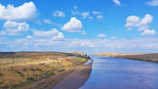
The Kazakh government plans to accelerate the second phase of the project to restore the Northern Aral Sea. Prime Minister Olzhas Bektenov has instructed the Ministry of Water Resources and Irrigation to secure financing for the second phase of the project by the end of 2026. The goal is to increase the volume of water in the Northern Aral Sea by around 10–11 billion cubic meters over the next four to five years. History of Degradation and Early Restoration Results The Aral Sea, which straddles the border between Kazakhstan and Uzbekistan, began to shrink rapidly in the 1960s due to large-scale irrigation projects that diverted water from the Amu Darya and Syr Darya rivers for cotton cultivation and other agricultural needs. As a result of the sea’s degradation, the Northern Aral Sea separated in 1987 and has since been sustained largely through the construction of the Kokaral Dam. In 2012, the sea and the Syr Darya delta were added to the Ramsar List of Wetlands of International Importance. Since then, Kazakhstan has undertaken systematic efforts to restore the northern part of the former Aral Sea. Unlike earlier efforts to save the Aral Sea as a whole, Kazakhstan’s approach since the mid-2000s has been shaped by a narrower and more pragmatic premise: that partial restoration is environmentally and politically achievable, while attempts to revive the entire basin are not. The construction of the Kokaral Dam marked a turning point, demonstrating that targeted hydraulic interventions could stabilise water levels, reduce salinity, and revive fisheries in the northern basin, provided expectations were kept within achievable limits. The recovery has already enabled the return of small-scale fishing, improved local livelihoods, and reduced dust storms from the exposed seabed around Aralsk. This strategy reflected a deliberate acceptance that restoring the Northern Aral would come at the expense of the southern basin, prioritising long-term ecological viability over symbolic ambitions. Over the past several years, roughly 5 billion cubic meters of water have been redirected into the Northern Aral Sea basin, increasing its total volume to more than 23 billion cubic meters. This exceeds the targets set out in Kazakhstan's Water Resources Management Concept, which had forecast reaching 20.6 billion cubic meters by 2025, with that volume previously expected only by 2029. [caption id="attachment_24691" align="aligncenter" width="2560"] Tastubek Bay, Northern Aral Sea; image: TCA, Stephen M. Bland[/caption] Infrastructure Plans and International Support With the support of the World Bank, Kazakhstan is considering raising the height of the Kokaral Dam by up to two meters and constructing a new hydraulic facility. These upgrades aim to increase both the volume and quality of water in the Northern Aral Sea, rehabilitate the Syr Darya delta, and reduce salt dispersion from the exposed seabed. The second phase of the initiative targets increasing the sea’s volume to 34 billion cubic meters. Bektenov has directed the Ministry of Water Resources and Irrigation to finalize technical preparations by mid-2026 and secure financing by the end of the year, including through international partnerships. The second phase...

Kazakhstan Warns of Severe Water Shortages as Syr Darya Levels Drop

Kazakhstan’s Minister of Water Resources and Irrigation, Nurzhan Nurzhigitov, gave a sober warning to the country on January 13 that this year there could be significantly less water for agriculture in the southern parts of the country. Nurzhigitov said that as of January 12, there was 1.9 billion cubic meters (bcm) less water in the reservoirs of southern Kazakhstan than on that date in 2025. The Importance of the Syr-Darya These areas are part of the Syr Darya Basin. The Syr Darya is one of Central Asia’s two large rivers, the other being the Amu Darya to the south, which runs along the Central Asia-Afghan border. Equally alarming for Kazakhstan, Nurzhigitov noted that in the mountains of upstream neighboring countries, Kyrgyzstan and Tajikistan, where the Syr Darya originates, officials are also reporting low levels in reservoirs. According to the Kazakh Ministry of Water Resources and Irrigation, the reservoirs in those two countries are a combined 3.2 bcm lower than last year at this time. Kyrgyzstan’s Energy Minister Taalaybek Ibrayev said in November 2025 that the water level in the massive Toktogul reservoir was less than 11 bcm, nearly 2 bcm lower than in November 2024, and only at about 60% of its 19.5 bcm capacity. Water from the reservoir is released into the Naryn River, which eventually merges with the Syr Darya in Uzbekistan, and flows on further into Kazakhstan. The Toktogul hydropower plant (HPP) depends on that water to supply some 40% of Kyrgyzstan’s domestically-produced electricity, and Ibrayev called on Kyrgyzstan’s citizens to conserve electricity and help the water in Toktogul accumulate before the 2026 agriculture season. Tajikistan’s state power company, Barqi Tojik, also called in November for the country’s citizens to save electricity as the water level at the Nurek HPP’s reservoir was low. The Nurek reservoir uses water from the Vakhsh River that does not flow into the Syr Darya, but the water shortage problems at Nurek are similar throughout Tajikistan, including tributaries that do flow into the Syr Darya. Conservation and New Wells In Kazakhstan, Nurzhigitov said inspections and repairs of irrigation canals were currently underway. He also mentioned that in December, Deputy Prime Minister Kanat Bozumbayev had ordered officials in the Kyzylorda, Turkestan, and Zhambyl provinces to hold meetings with farmers and herders to discuss water conservation. There were also talks with farmers about planting crops that required less water. Water limits would be announced in February, Nurzhigitov said, and in March the Agriculture Ministry would decide how much land to sow for this year’s crops based on expected water supplies during the spring-summer period. Nurzhigitov added that work was being done to increase the use of underground water, which he claimed could amount to some 15.7 bcm of extra water for Kazakhstan annually. Currently, Nurzhigitov said, only some 7-10% of this underground water is being used. Bleak Forecast Kazakhstan gathered a record harvest in 2025, some 27.1 million tons of grain, despite planting less wheat. Given the reduction in precipitation in Central Asia in...

Central Asian Countries Agree on 2026 Water Allocations from Amu Darya and Syr Darya

Central Asian states have reached an agreement on water allocations from the Amu Darya and Syr Darya rivers for 2026. The decision was made during the 91st meeting of the Interstate Coordination Water Management Commission (ICWC), held in Ashgabat on November 13, 2025, according to Kun.uz. At the meeting, the countries agreed on how water resources will be managed during the 2025–2026 non-growing season, the period when agricultural demand is low. For the Amu Darya, the total allocation from October 2025 to October 2026 is set at approximately 55.4 billion cubic meters, with 15.9 billion cubic meters designated for the cold months from October through April. Under the agreement, Tajikistan will receive 9.8 billion cubic meters, while Turkmenistan and Uzbekistan will each receive 22 billion. A key provision is that roughly 44 billion cubic meters of the Amu Darya’s flow must reach the Kerki hydrological station in Turkmenistan to sustain downstream areas. Additionally, 4.2 billion cubic meters is allocated to support the Aral Sea and the Amu Darya delta, with half to be delivered in winter and early spring. Another 800 million cubic meters will be used for irrigation in Dashoguz, Khorezm, and Karakalpakstan. These allocations are crucial for both communities living in water-scarce regions and for preserving fragile river ecosystems. For the Syr Darya, the total allocation for the non-growing season is 4.219 billion cubic meters. Of this, Uzbekistan will receive the majority share, 3.347 billion cubic meters. Kazakhstan will receive 460 million cubic meters through the “Dustlik” canal, Tajikistan 365 million, and Kyrgyzstan 47 million. These figures are based on projected river inflows, reservoir capacities, and the need to maintain ecological flows. The ICWC also approved operational plans for key reservoirs. In Tajikistan, the Nurek Reservoir is expected to enter the non-growing season with 10.5 billion cubic meters and decline to around 9.7 billion by spring. The Tuyamuyun reservoir, located on the Uzbekistan–Turkmenistan border, will start with 4.5 billion cubic meters and reduce to 3.4 billion. Both will gradually release water to support irrigation and sustain the Amu Darya’s flow. In the Syr Darya basin, total water volume in the Toktogul, Andijan, and Charvak reservoirs at the beginning of the season is approximately 10.6 billion cubic meters, slightly below average. Tajikistan’s Bahri Tojik reservoir is expected to contain 2.6 billion cubic meters, while Kazakhstan’s Chardara reservoir will hold about 1.65 billion. Collectively, the Syr Darya basin will have around 14.9 billion cubic meters of water at the start of winter, roughly 90% of the long-term seasonal average. The 92nd ICWC meeting is scheduled to take place in Dushanbe, where officials will assess reservoir performance and water usage during the 2025-2026 season. The agenda will also include strategies to strengthen regional water security in the face of escalating climate pressures.

Planting Trees to Heal Old Wounds: Can a Desert Forest Save the Aral’s Last Residents?

In the Aralkum Desert, afforestation campaigns have multiplied since the early 2000s. They are meant to slow the sandstorms, temper a rapidly warming climate, and protect the health of those still living in the shadow of the Aral Sea. But the promised results have not appeared yet. The road from Aralsk to Aiteke Bi cuts through a palette of ochre and dust. Trucks drift forward in pale clouds, dragging the desert behind them like a long train. In these villages scattered along the former shoreline of the Aral Sea, the wind never leaves. It is abrasive, restless, and a witness to a vanished water body that once cooled the hottest corner of Kazakhstan. Respiratory diseases now run through family histories, and doctors say they can recognize lungs shaped by ecological collapse. At the polyclinic in Aiteke Bi, patients describe the same symptoms with weary precision: breath shortening too quickly, coughs that never fully recede, a fatigue that never seems to lift. Nuralay, 52, says the storms “get into the house, into the throat, into everything.” She admits she cannot remember a season without irritation in her chest. For Dr. Kuanyshqar Assilov, who has watched the pattern deepen for years, the cause is unmistakable: decades of airborne salts, pesticide residues, and industrial chemicals lifted from the dried seabed of the Aral Sea. [caption id="attachment_39897" align="aligncenter" width="1378"] In Aralsk, sand covers everything[/caption] Marat Narbaev, executive director of the International Fund to Save the Aral Sea (IFAS), recounts the disaster’s origins with a mixture of resignation and habit. He traces it back to the 1960s, when Soviet planners diverted the Amu Darya and Syr Darya to feed cotton monocultures. “The cotton was used to make clothing for soldiers and ammunition,” he says. Today, he argues, the basin faces two pressures: “climate change and demographic growth. Fifty million inhabitants… soon seventy.” In this landscape, the promise of restoring the region through afforestation has acquired symbolic weight. Saxaul trees - hardy, grey-green, capable of surviving in brackish soils - are planted by the millions on the exposed seabed. Officially, they are meant to stabilize sand, calm storms, and cool the surface. Unofficially, they carry the hope that life here might once be breathable again. Survivalist tree? On paper, the saxaul is a biological survivalist: roots plunging more than 30 feet deep, the ability to stabilize dunes, lower surface salinity, and grow dense enough within a few years to slow the wind. In Aralkum, a village east of Aralsk, residents praise the planting that lines a dozen houses. “It really worked, the storms became more bearable,” a man says. Then he shrugs: more trees should have been planted. “We asked for the other side of the village, but there’s no funding left.” Nowadays, half of the trees have died, and the rest lie buried beneath the dunes. [caption id="attachment_39896" align="aligncenter" width="1378"] In Aralkum village, half of the surviving trees barely emerge from the sand[/caption] Sometimes, past plantations have almost zero trees left. According to a 2021...

Opinion: The Integration of Afghanistan into Central Asia

Shared rivers and joint water management can shape a new regional partnership Central Asia and Afghanistan sit on the same rivers, yet often behave as if they belong to different regions. Water ties them together more firmly than any border, but the politics of the past have kept Afghanistan outside the regional system. Today, as climate pressures intensify and development accelerates on both sides of the Amu Darya, the case for integrating Afghanistan into Central Asia has never been stronger. And the path to that integration begins with water. The debate around the Qosh Tepa Canal makes this evident. Afghanistan was never part of the agreements that govern the Amu Darya River (Protocol 566 of the Soviet Union and the Almaty 1992 agreement). It did not sign allocation protocols and never joined regional basin institutions. Still, it was expected to follow rules it had no hand in shaping. Now, that old arrangement has reached its limit. The canal will bring new agriculture to the north of Afghanistan, but downstream states depend on the same river. The real question is not whether Afghanistan should develop, but how to shape that development jointly so the river can sustain all sides. Central Asia already has cooperative models that Afghanistan could join. Uzbekistan and Tajikistan have shown how two neighbors can jointly manage a transboundary river through their collaboration in hydropower on the Zarafshan. Kyrgyzstan, Uzbekistan, and Kazakhstan have signed a similar mechanism with the KambarAta-1 project, which will generate energy and regulate seasonal flows for downstream agriculture. These experiences show that once countries share responsibility for a river, trust can grow and benefits expand. Afghanistan can become part of this regional architecture. The 161-meter-high planned dam on the Kokcha River, set to generate 445 megawatts of electricity, offers a clear entry point. A jointly governed dam on this river would give Afghanistan energy, while downstream states would benefit from its flow in terms of agriculture. When operations are transparent and agreed upon, water becomes a field of cooperation rather than tension. Energy trade adds another layer of opportunity. Central Asia has a long record of exchanging electricity and gas in return for upstream releases. Uzbekistan and Kazakhstan have done this with Kyrgyzstan for many years through a joint water and energy agreement. The same model can work with Afghanistan. The country needs power, and it can offer coordinated water management in return. A structured energy for water arrangement would give Afghanistan an incentive to cooperate and offer Central Asia predictability. Agriculture is another arena where cooperation promises immediate gains. Uzbekistan’s policies on water-saving technologies offer a strong example. They subsidize drip, sprinkler systems, canal improvement, land levelling, efficient pumps, and even solar-powered irrigation. These investments reduce water losses while increasing yields only if their rebound effect, such as further expansion of agriculture, is controlled. The same approach could be applied in the northern provinces of Afghanistan, including in the area under the Qosh Tepa Canal. With similar financial support and technical guidance, Afghan...

Afghanistan’s Qosh Tepa Canal Raises Water Security Fears

Water has long been one of Central Asia’s most contested resources, shaping agriculture, energy policy, and diplomacy across the region. Recently, Afghanistan’s Qosh Tepa Canal project has emerged as a central point in this debate. Promoted by the Taliban as a vital step toward achieving food security and economic growth, the canal also raises alarm bells among downstream neighbors who heavily depend on the Amu Darya River. Now, according to Islamic Emirate spokesman Zabihullah Mujahid, the second phase of the project is expected to be completed within five months, raising further concerns among downstream countries about its potential impact on regional water security. Progress on the Ground In August, the Afghan authorities stated that 93% of the second phase had been completed. Videos show the canal lined with concrete and stone in some sections, alongside the construction of large and medium-sized bridges to link surrounding settlements. The project spans 128 kilometers from Dawlatabad district in Balkh province to Andkhoy district in Faryab province and involves over 60 contractors, making it one of Afghanistan’s largest infrastructure projects. Origins and International Support The canal’s roots trace back to earlier international efforts. While some sources attribute its conceptual origins to Soviet or British engineers in the 1960s, significant development began in 2018 under President Ashraf Ghani. The project was supported by the U.S. Agency for International Development (USAID) and Indian engineering firms. According to the Scientific-Information Center of the Interstate Commission for Water Coordination (SIC ICWC), a $3.6 million feasibility study was launched in Kabul in December 2018, funded by USAID and conducted by AACS Consulting and BETS Consulting Services Ltd. The study was coordinated with several Afghan ministries, but has not been published. Following the Taliban’s takeover, the Islamic Emirate held an official inauguration ceremony on March 30, 2022. The full canal is designed to stretch 285 kilometers, measuring 100 meters wide and 8.5 meters deep, and is expected to divert an estimated six to ten cubic kilometers of water annually from the Amu Darya. Afghan media have quoted water management expert Najibullah Sadid, who projected the canal could generate between $470 million and $550 million in annual revenue. Regional Concerns and Environmental Risks The project has raised alarm in Uzbekistan, Turkmenistan, and Tajikistan, countries that depend heavily on the Amu Darya for irrigation. Experts at SIC ICWC point out that no environmental impact assessment was conducted for downstream states, nor were they formally notified of the construction, as required by international water conventions. In December 2022, Uzbek President Shavkat Mirziyoyev called for practical dialogue with Afghanistan and the international community to strengthen regional water security. Adroit Associates estimates that the canal could eventually divert up to 13 billion cubic meters annually, nearly one-quarter of the Amu Darya’s average flow. Environmental risks are also mounting. Analysts warn that Uzbekistan, which relies heavily on the river for agriculture, could face soil degradation and declining crop yields. Turkmenistan, where agriculture accounts for 12% of GDP, may also suffer severe disruptions. Some studies suggest Uzbekistan and...