• KGS/USD = 0.01143 0%
  • KZT/USD = 0.00205 0%
  • TJS/USD = 0.10724 0.09%
  • UZS/USD = 0.00008 0%
  • TMT/USD = 0.28571 0%
  • KGS/USD = 0.01143 0%
  • KZT/USD = 0.00205 0%
  • TJS/USD = 0.10724 0.09%
  • UZS/USD = 0.00008 0%
  • TMT/USD = 0.28571 0%
  • KGS/USD = 0.01143 0%
  • KZT/USD = 0.00205 0%
  • TJS/USD = 0.10724 0.09%
  • UZS/USD = 0.00008 0%
  • TMT/USD = 0.28571 0%
  • KGS/USD = 0.01143 0%
  • KZT/USD = 0.00205 0%
  • TJS/USD = 0.10724 0.09%
  • UZS/USD = 0.00008 0%
  • TMT/USD = 0.28571 0%
  • KGS/USD = 0.01143 0%
  • KZT/USD = 0.00205 0%
  • TJS/USD = 0.10724 0.09%
  • UZS/USD = 0.00008 0%
  • TMT/USD = 0.28571 0%
  • KGS/USD = 0.01143 0%
  • KZT/USD = 0.00205 0%
  • TJS/USD = 0.10724 0.09%
  • UZS/USD = 0.00008 0%
  • TMT/USD = 0.28571 0%
  • KGS/USD = 0.01143 0%
  • KZT/USD = 0.00205 0%
  • TJS/USD = 0.10724 0.09%
  • UZS/USD = 0.00008 0%
  • TMT/USD = 0.28571 0%
  • KGS/USD = 0.01143 0%
  • KZT/USD = 0.00205 0%
  • TJS/USD = 0.10724 0.09%
  • UZS/USD = 0.00008 0%
  • TMT/USD = 0.28571 0%

Viewing results 19 - 24 of 668

Opinion: Can the Aral Sea Be Saved? Central Asia’s Water Cooperation Test

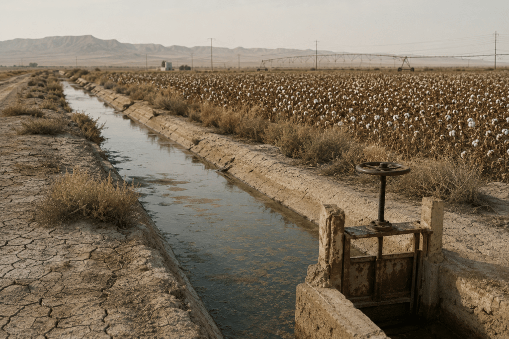
For most people, the Aral Sea is known through climate documentaries and satellite images as shorthand for ecological disaster. Once the world’s fourth-largest lake, it withered after Soviet planners diverted its two lifelines, the Amu Darya and Syr Darya, to turn Central Asia into a cotton empire. Over almost five decades, as much as three-quarters of the water in these river systems has leaked into desert soils rather than reaching the sea. NASA satellite data show that the blue inland ocean has been replaced by dusty basins. We all know that story. But the more urgent question is different: can the Aral Sea still be “saved” in any meaningful sense, in a century of climate stress and water shortages? Is it still capable of being restored to health? The honest answer is yes, but only if Central Asian states and their international partners stop treating it as a frozen symbol of Soviet failure and begin governing the entire basin as a shared, climate-vulnerable commons. Anything less is nostalgia with good drone footage. From Lake to Warning Signal The Aral Sea once covered about 68,000 square kilometers and supported fishing communities along what is now the Kazakhstan-Uzbekistan border. Before the large-scale Soviet irrigation projects of the 1960s, its level depended mainly on inflow from the Amu Darya and Syr Darya, with smaller contributions from precipitation and groundwater. In the arid climate of the basin, the sea’s stability depended on a fragile balance between river inflow and water loss through evaporation. That balance began to collapse after Soviet planners expanded irrigation for cotton and rice, diverting water from rivers that had fed the sea for centuries. Evaporation continued while river inflow fell, and the sea shrank rapidly. By the early 2000s, time-lapse images published by NASA’s Earth Observatory showed large areas of deep blue water turning into exposed seabed and dust plains within a generation. The consequences went far beyond a retreating shoreline. As the water receded, the exposed seabed became the Aralkum Desert, a source of toxic dust contaminated with salt as well as fertilizer and pesticide residues. Winds carry that dust across farms and towns, degrading soil and crops while exposing residents to serious health risks. The IFAS Agency in Uzbekistan, a working body of the International Fund for Saving the Aral Sea, coordinates projects and programs in the Aral Sea basin. The collapse of fisheries also devastated local livelihoods and food supplies. Researchers have linked the wider Aral Sea crisis to higher rates of respiratory disease and anemia. Some studies have also reported elevated cancer risks. The loss of such a large body of water has changed the local climate. Without the sea’s moderating effect, summers have become hotter and drier, while winters have become colder. These pressures are now compounded by climate change and the retreat of glaciers in the upstream mountains that feed Central Asia’s river systems. The Aral Sea is therefore more than an environmental tragedy. It is a warning of what can happen when political...

From Ancient Aryks to AI: Almaty Student Proposes Digital Water Solution

In Almaty, 10th-grade student Amir Alniyazov has developed an artificial intelligence project called ARYK.AI that aims to help city services respond more quickly to clogged aryk channels, localized flooding, and water overflow after heavy rainfall. At first glance, the issue may appear purely municipal: aryks, trash, leaves, rainwater, and utility workers clearing blocked channels. But the aryk system is tied to a much longer urban history. In Central Asia, an aryk is not simply a ditch. It is a traditional water channel that has helped sustain settlements in dry climates for centuries. Aryks irrigated gardens, cooled streets, supplied water, and made urban life possible in parts of the region where summer heat and limited rainfall shaped daily life. In foothill cities such as Almaty, they also became part of the city’s drainage infrastructure. Almaty’s modern aryk network developed during the Verny period, when the city was under Russian imperial rule. By the late 19th century, aryks had become an important part of urban infrastructure. In 1899, a main aryk was built to help distribute water through the city. During the Soviet period, many aryks were lined with stone or concrete, gradually shifting from simple irrigation channels into a visible part of the city’s stormwater system. But the 21st century has brought new pressures. Almaty has expanded rapidly, traffic has increased, and more of the city has been covered with asphalt. Leaves, garbage, and household debris continue to accumulate in aryks. As a result, a system that once quietly carried water through the city is now also expected to help manage urban flooding. [caption id="attachment_49362" align="aligncenter" width="1200"] From a personal photo archive[/caption] Where residents once monitored aryks through daily observation, modern Almaty faces a more complex problem: heavier traffic, denser construction, more paved surfaces, and faster information flows. Alniyazov’s project attempts to bring one of the city’s oldest water systems into the digital age. That is the idea behind ARYK.AI. The system combines AI, water-level sensors, a Telegram bot, an online monitoring map, and routing technology for municipal services. The concept is straightforward. If water levels in an aryk rise sharply, or if trash, silt, leaves, or fallen branches begin to accumulate, the system is intended to issue an early warning before the problem turns into flooding on city streets. The project has two main components. The first is citizen reporting. Residents and visitors to Almaty can use a Telegram bot based on a “single-window” principle to report flooding, blockages, and other problems. Users can attach photos, videos, and geolocation data. AI then processes the information, identifies the nature of the problem, and assesses how urgently municipal services need to respond. The second component relies on sensor data. Water-level sensors installed above aryks can transmit real-time information to the digital platform. If the water rises to a critical level, the system records an alert and sends it to the monitoring program. This is where the system’s more advanced functionality begins. The AI does not simply collect complaints and sensor readings for later...

Turkmenistan Has World’s Highest Freshwater Withdrawal Per Capita

Turkmenistan has recorded the world’s highest annual freshwater withdrawal per capita, a ranking that points to the heavy strain placed on water resources by irrigated agriculture, particularly cotton production, according to international data based on statistics from the UN Food and Agriculture Organization (FAO) and the World Bank. The country’s position at the top of the ranking is driven not by household consumption, but by the massive use of water in agriculture, particularly in the cotton sector. The ranking is therefore less a measure of individual water use than an indicator of structural dependence on irrigation in an extremely arid country. According to the data, more than 3,631 cubic meters of freshwater are withdrawn annually for every resident of Turkmenistan. The calculations include not only domestic water usage, but also volumes consumed by agriculture, industry, and municipal infrastructure. The figure reflects Turkmenistan’s dependence on large-scale irrigation systems established during the Soviet period to support cotton production. Vast amounts of water are diverted from the Amu Darya River to agricultural land in one of the world’s driest climates. Researchers note that these irrigation projects were among the major causes of the environmental catastrophe that devastated the Aral Sea. Agriculture remains the world’s largest consumer of freshwater. According to international estimates, the agricultural sector accounts for roughly 70% of global freshwater use. As a result, the highest positions in the ranking are largely occupied by countries with arid climates and extensive irrigated farming systems. The top 15 countries also include Kazakhstan, Uzbekistan, Kyrgyzstan, Tajikistan, Azerbaijan, and Iran. At the opposite end of the ranking are countries with the world’s lowest levels of freshwater withdrawal per capita. These include the Democratic Republic of Congo, with just seven cubic meters per person annually, as well as Equatorial Guinea and the Maldives, with 11 cubic meters each. Climate change is already increasing pressure on water resources across many regions of the world. Droughts, rising temperatures, and growing agricultural demand are making efficient water management an increasingly urgent issue, including for the countries of Central Asia. For Central Asia, the figures underline a familiar problem: water use remains shaped by Soviet-era irrigation systems, while climate change is making the region’s rivers, reservoirs, and agricultural systems more vulnerable.

Tajikistan and UN to Host Water Crisis Conference in Dushanbe

Tajikistan and the United Nations will co-host the 4th High-Level International Conference on the International Decade for Action "Water for Sustainable Development " 2018-2028 next week, as Central Asia and other regions face increasing water scarcity because of climate change, higher consumption, and other factors. Delegates to the May 25-28 water conference in Dushanbe include government officials, scientists, executives from financial institutions and civil society members from around the world. The goal of creating “sustainable” water resources is especially critical in Central Asia, where there is growing concern that shortages could threaten public health and stir tension between upstream and downstream countries. Kyrgyzstan and Tajikistan, for example, are in mountainous regions and have relatively significant water resources that they share with neighboring countries. However, the resources are under strain. Kazakhstan, Uzbekistan and Turkmenistan, in turn, rely on the cross-border water supply that flows downstream. Central Asian governments have begun joint projects on water infrastructure to avoid the kind of tensions that emerged in the past. The Dushanbe conference is another step in that process, even though the event is global in perspective. Tajik diplomats have held briefings in Azerbaijan, Saudi Arabia and other countries to promote the conference, describing Tajikistan as a leader in “water diplomacy” as the world faces a water crisis that is increasingly evident in floods, droughts, pollution and melting glaciers. Dushanbe has already hosted several international conferences on water. Saidjon Shafizoda, spokesman for Tajikistan’s Ministry of Foreign Affairs, said at a briefing in the Tajik capital on Wednesday that the conference can help accelerate innovation and mobilize funding for the “sustainable and inclusive” management of water, the state Khovar news agency reported. Organizers say more than 2,500 people are expected to participate.

Pamir Glaciers Rapidly Melting Even Above 5,000 Meters, Tajik Scientists Warn

Tajik scientists have conducted the country’s first direct winter field measurements of snow dynamics on a Pamir glacier since independence, with findings showing a sharp decline in snow reserves and accelerated melting even in high-altitude zones previously considered relatively stable. The expedition took place from May 6-15 on Glacier No. 457, located in the upper basin of the Nukhchashma River, also known as Tokuzbulak, a tributary of the Gunt River. The research was carried out by specialists from the Mountain Societies Research Institute at the University of Central Asia (UCA), together with the Center for Research of Glaciers of Tajikistan’s National Academy of Sciences, as part of the United Nations initiative “Decade of Action for Cryospheric Sciences, 2025-2034.” The scientists’ primary objective was to study the glacier’s winter mass balance by analyzing snow accumulation, density, and distribution across the glacier surface. According to the organizers, these are the first direct winter field measurements of glacier winter snow dynamics conducted in Tajikistan since the country gained independence. The work comes as glacier preservation is receiving growing international attention. The United Nations says rapid glacier melt threatens billions of people, especially those who depend on glaciers for drinking water, agriculture, and energy. Tajikistan’s glaciers are particularly important for Central Asia because they feed rivers that support downstream communities, irrigation, and hydropower. Previous glacier monitoring efforts in Tajikistan were largely limited to summer expeditions and satellite observations. Denis Samyn, senior research fellow and professor of Earth and environmental sciences at UCA, said Central Asia’s glaciers had remained insufficiently studied for decades. “Now, with support from the state and international partners, the region is gradually developing its own school of cryospheric research and a new generation of specialists,” he said. Scientists expressed particular concern over the latest monitoring results. UCA researcher Hofiz Navruzshoev said Glacier No. 457 has been monitored annually since 2020, although previous studies primarily focused on summer melting. “The 2025 observations revealed a critical situation: the glacier’s thickness decreased by more than one meter, which is a very significant indicator,” he said. According to Navruzshoev, seasonal snow cover in the glacier’s accumulation zone at elevations above 5,100 meters has virtually disappeared over the past five years. This means the glacier is no longer replenishing lost ice even in its upper accumulation areas, which traditionally served as long-term snow storage zones. That trend is significant because the accumulation zone is the part of a glacier where winter snow normally survives long enough to compact into ice. If that zone stops gaining snow, the glacier can lose mass even before lower-elevation melting is taken into account. The expedition operated under difficult high-altitude conditions, with researchers working at elevations of around 5,000 meters amid rapidly changing weather, snowfall, strong winds, and near-zero visibility. During the mission, scientists dug five snow pits at elevations ranging from 4,790 to 5,012 meters, measured snow depth and density, and collected data on glacier snow reserves. The findings add to wider scientific concern about the Pamirs. The Times of...

Central Asian Countries Rank Among World’s Highest Water Consumers

Several Central Asian countries rank among the world’s highest consumers of water per person, according to data compiled by the Worldometer portal. The figures, based on statistics from UN agencies including UNESCO and the UN Food and Agriculture Organization (FAO), place Turkmenistan first globally, with Uzbekistan, Tajikistan, and Kyrgyzstan also in the top ten. The figures highlight a long-standing regional challenge: heavy dependence on water-intensive agriculture combined with aging irrigation systems that lose substantial amounts of water before it reaches fields. Turkmenistan leads the global ranking with daily water consumption of 15,445 liters per person. Uzbekistan ranks fourth worldwide at 4,778 liters per capita per day, followed by Tajikistan with 4,460 liters and Kyrgyzstan with 4,153 liters. Kazakhstan recorded the lowest level among Central Asian states, at 3,397 liters per person daily, though that still places it among relatively high-consuming countries internationally. In terms of total annual water use, Uzbekistan consumes the largest volume in the region at 54.56 billion cubic meters a year. It is followed by Turkmenistan with 27.9 billion cubic meters, Kazakhstan with 22.77 billion, Tajikistan with 11.49 billion, and Kyrgyzstan with around 8 billion cubic meters. Experts say agriculture explains much of the region’s high consumption. Globally, farming accounts for about 70% of freshwater use, compared with 20% for industry and 10% for households. In Central Asia, agriculture represents more than 80% of water consumption, while up to 40% of water is estimated to be lost through deteriorating irrigation infrastructure. The problem has become increasingly significant as freshwater demand rises worldwide. According to UN estimates, freshwater withdrawals have tripled over the past 50 years, while global demand continues to grow by around 64 billion cubic meters annually because of population growth, changing consumption patterns, energy production, and biofuel development. Several Central Asian governments have begun introducing reforms aimed at reducing water losses. In Uzbekistan, authorities joined the World Bank’s Water Forward initiative and announced plans to expand water-saving technologies across 4.1 million hectares of irrigated farmland while reducing irrigation losses by 25%. Kazakhstan has also faced recurring shortages. Seasonal water restrictions are regularly introduced in southern regions, and this year the government approved consumption limits because of expected shortages during the agricultural season. The issue is closely linked to energy production in upstream countries. Studies by the Organization for Economic Co-operation and Development (OECD) indicate that more than 80% of electricity generation in Kyrgyzstan and Tajikistan comes from hydropower, creating a close link between irrigation needs and energy supply. Limited coordination over water releases and electricity generation has contributed to summer shortages in some years. The figures show the scale of the challenge for Central Asian governments seeking to reduce water losses and manage shared rivers more effectively.