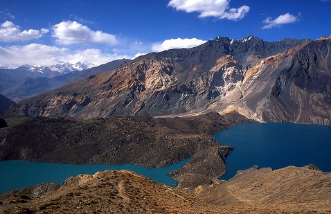
Earthquakes Rekindle Fears Over Lake Sarez
On the evening of January 30th, an earthquake struck in the Gorno-Badakhshan Autonomous Province on the border between Tajikistan and Xinjiang. Though this instance only had a magnitude of 4.4, it comes in the wake of the magnitude 7 quake which pounded the China-Kyrgyzstan border on January 23rd, shaking buildings in Almaty. As recently as February 2023, a series of earthquakes, the largest measuring 6.8, hit forty miles west of Murgab on the border between Tajikistan and China’s Xinjiang province. This was the eighteenth such instance measuring 6.5 or more over the course of the last century, and serves to focus attention on extremely remote Lake Sarez in Tajikistan. [/vc_column_text][vc_single_image image="14212" img_size="full" el_class="scond-image" parallax_scroll="no" woodmart_inline="no"][vc_column_text woodmart_inline="no" text_larger="no"]Plan of Lake Sarez and the Usoi Dam, 1913 At five-hundred-meters deep and 47 miles long, mountainous Lake Sarez contains more than 3.85 cubic miles of water. It was formed in 1911, when a 2.2 billion cubic meter landslide caused by an earthquake with an estimated magnitude of 6.5-7.0 blocked the Bartang River’s path. The sound of the quake was recorded over 2,350 miles away at the Pulkovo seismic station near St. Petersburg. Thus, the tallest natural dam in the world, the three-mile long, 567-meter high Usoi Dam was formed, whilst the villages of Usoi and Sarez were buried beneath the landslide and the lake, respectively, killing 302 people. According to the two survivors, the dust clouds cleared only after some days to reveal a mountain where the village of Usoi used to stand. The lake has been a potential disaster waiting to happen ever since. In 1968, a landslide caused two-meter-tall waves to rock the lake, and with glacial melting causing water levels to rise by eight inches a year, pressure on the natural dam is building. As early as the 1970s, plans were hatched to harness the lake as a hydroelectric power station, but technical issues and its far-flung location saw the scheme come to nothing. In 2018, a deal was signed with Hong Kong-based Heaven Springs Harvest Group to sell the lake’s “blue gold” as drinking water, but inaccessibility again largely scuppered the project.[/vc_column_text][vc_single_image image="13414" img_size="full" el_class="scond-image" parallax_scroll="no" woodmart_inline="no"][vc_column_text woodmart_inline="no" text_larger="no"]Murgab Bazaar, Gorno-Badakhshan - Photo: Times of Central Asia Back in 1997, a gathering of experts in Dushanbe concluded that the Usoi Dam was unstable. Their findings suggested that a powerful earthquake could precipitate a collapse of the dam. However, a study conducted by the World Bank in 2004 contradicted these conclusions, arguing that the dam was, in fact, stable. Nevertheless, the main threat identified was not the dam's general stability but a specific geological feature - a partially detached mass of rock, approximately 0.72 cubic miles in size. There are concerns that this precarious massive rock formation could detach and plunge into the lake. This event could trigger a catastrophic flood, and, as such, while the dam itself may be stable, the potential for disaster still looms large. In this earthquake-prone environment, were the dam to be breached a tidal...


